
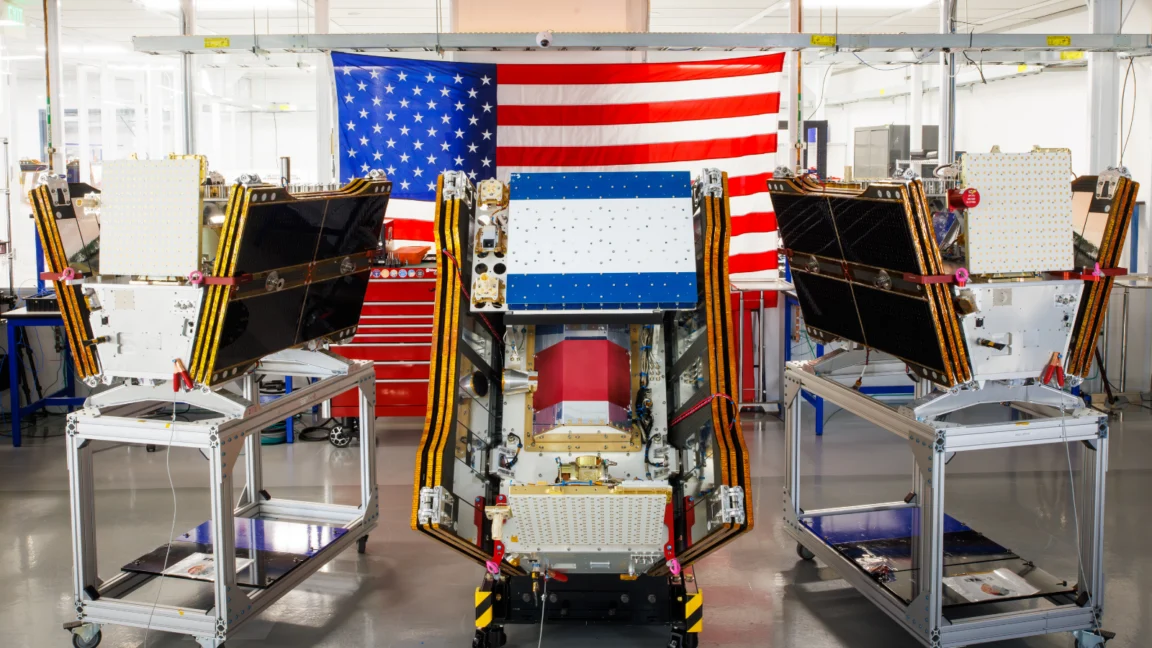
As vast plumes of smoke from hundreds of raging wildfires continue to blanket regions across Canada and the United States, a significant technological advancement in wildfire detection has reached a critical milestone. On July 7, 2026, the first three operational satellites of the Google-backed FireSat program successfully launched into orbit aboard a SpaceX Falcon 9 rocket from Vandenberg Space Force Base in California. This deployment marks a pivotal transition to "initial operational capability" for the FireSat constellation, managed by the nonprofit Earth Fire Alliance. Following a three-month testing period, these cutting-edge microsatellites are poised to begin providing unprecedented wildfire detection data to fire agencies across the United States, Australia, and Europe before the end of the year, promising to spot even the smallest fires that often evade conventional monitoring systems.
The escalating global wildfire crisis has underscored an urgent need for more sophisticated and rapid detection capabilities. Over the past decade, the frequency, intensity, and destructiveness of wildfires have dramatically increased, driven largely by climate change, prolonged droughts, and changes in land use. Traditional methods of wildfire detection, including ground patrols, aerial surveillance, and existing satellite networks, have struggled to keep pace with the scale of the threat. Many current satellites, designed primarily for broader meteorological or environmental monitoring, often miss nascent fires obscured by smoke or clouds, or those that are simply too small to register. This delay in detection can allow small blazes to rapidly escalate into uncontrollable megafires, causing catastrophic damage to ecosystems, property, and human lives.
A Chronology of Development and Deployment
The journey to FireSat’s operational launch has been a carefully planned and technologically intensive endeavor. The program gained significant momentum with substantial financial backing from major tech entities and philanthropic organizations. Google has committed over $15 million to support the initial deployment, recognizing the transformative potential of AI-powered satellite imagery in climate resilience efforts. Further bolstering the initiative, the Bezos Earth Fund pledged an additional $26 million, highlighting a shared commitment to addressing environmental challenges through innovative solutions.
The technical backbone of the FireSat constellation is provided by California-based satellite manufacturer Muon Space, which designed and built these specialized microsatellites. The program’s capabilities were first rigorously tested with the launch of a FireSat Protoflight satellite in March 2025. This precursor mission proved highly successful, collecting more than one million images and demonstrating its ability to detect low-intensity blazes that were invisible to existing satellite infrastructure. This protoflight validation was crucial in confirming the efficacy of FireSat’s advanced imaging technology.
The July 7, 2026 launch of the first three operational satellites represents a significant leap from proof-of-concept to active deployment. These initial satellites will undergo a critical three-month testing and calibration phase to ensure optimal performance and data accuracy. By the end of 2026, they are expected to be fully integrated into global fire management systems, providing vital data to early adopter organizations. These include fire agencies in high-risk regions such as California and Colorado in the United States, as well as partners in Australia and Portugal, all of whom are on the front lines of the global wildfire battle.

The long-term vision for the FireSat program is ambitious, aiming for a full constellation of more than 50 satellites. This expansive network is projected to provide global imagery coverage on an hourly basis by 2029. Further expansion into the early 2030s promises even more frequent updates, with imagery becoming available every 20 minutes, offering near real-time tracking of wildfire activity worldwide.
Technological Edge: Peering Through the Haze
What sets FireSat apart is its purpose-built design for wildfire detection. Each satellite is equipped with advanced multispectral imaging capabilities specifically engineered to overcome the common challenges of smoke and cloud cover. Unlike general-purpose satellites, FireSat’s sensors can penetrate dense smoke plumes and atmospheric haze, offering clear views of ground-level heat signatures. This allows the system to detect fires as small as five by five meters (approximately 16 by 16 feet) – a level of granularity that is critical for early intervention.
The ability to spot such small fires is a game-changer. Often, by the time a wildfire becomes visible to conventional satellite systems or ground patrols, it has already grown significantly, making suppression efforts more difficult, dangerous, and costly. By identifying fires in their nascent stages, FireSat provides a crucial window for rapid response teams to contain blazes before they escalate into major incidents.
Google Research plays a vital role in maximizing the utility of FireSat’s data. Leveraging the company’s powerful AI models, Google Research plans to process and analyze the operational FireSat data, comparing it with historical images to accurately identify even the faintest fire signals. Furthermore, these AI models will be instrumental in informing predictive modeling of wildfires, helping agencies anticipate fire behavior, identify high-risk areas, and allocate resources more effectively. Google celebrated the launch, describing it as "another tangible step forward in putting practical AI to work for climate resilience," emphasizing the fusion of advanced technology with urgent environmental needs.
Projected Impact: Saving Lives, Land, and Resources
The potential benefits of FireSat’s enhanced detection capabilities are immense, extending beyond mere early warning. The Earth Fire Alliance has released compelling projections that highlight the program’s anticipated positive impact. Even with an hourly revisit rate, the FireSat constellation is expected to help save more than $1 billion in fire damage costs annually. This economic saving stems from reduced property destruction, infrastructure damage, and the costs associated with large-scale firefighting operations.

Beyond financial implications, the environmental and social benefits are equally significant. The Alliance projects that early detection could prevent nearly 22 million tons of carbon emissions each year. Wildfires are major contributors to atmospheric carbon, exacerbating climate change in a destructive feedback loop. By mitigating the spread of large fires, FireSat can help reduce these emissions. Furthermore, the program is anticipated to protect approximately 3,500 homes and safeguard 1.3 million acres of land annually, preserving vital ecosystems, biodiversity, and human communities. These figures underscore the profound potential of FireSat to revolutionize wildfire management and contribute substantially to climate resilience efforts worldwide.
The Broader Wildfire Conundrum: Beyond Detection
While FireSat represents a monumental leap in detection technology, it operates within a broader, complex landscape of wildfire management. Detection, while critical, is just one component of a multi-faceted strategy required to combat the intensifying global wildfire crisis. Fire agencies also need sufficient resources for ecosystem management, including prescribed burns to reduce fuel loads, and adequate personnel and equipment to actively suppress unwanted fires. Their job has become increasingly challenging due to the pervasive influence of global warming.
The current wildfire season in Canada provides a stark illustration of these challenges. As of July 17, the Canadian Wildland Fire Information System reported nearly 900 active wildfires across the country, with over 3,600 wildfires recorded year-to-date, burning more than 6.6 million acres. The boreal forests, particularly susceptible to intensified burning due to rising temperatures and prolonged dry spells, have seen unprecedented levels of destruction. This summer’s blazes have forced thousands of people, including numerous First Nations communities, to evacuate their homes, disrupting lives and cultures. Moreover, the pervasive smoke clouds have generated hazardous air pollution, impacting over 100 million people across Canadian and US cities, underscoring the far-reaching consequences of these infernos.
As Werner Kurz, a retired senior research scientist at Natural Resources Canada, succinctly told The Atlantic, "What is unfolding is what climate and forest scientists have been predicting for 30 years. That as the world gets hotter and drier, we are exposing forests to more and more risk, and the old strategies of fire suppression are simply being overwhelmed." Indeed, Canada has experienced two of its most destructive wildfire seasons in 2023 and 2025, with the last three years ranking among the ten worst on record. This trend highlights the inadequacy of traditional fire suppression tactics alone in the face of rapidly changing climatic conditions.
Fighting wildfires in vast, often uninhabited forest regions demands specialized resources, including fixed-wing air tankers capable of dropping fire retardants and heavy-lift helicopters for water drops and transporting firefighting crews to remote sites. Historically, individual Canadian provinces have borne the primary burden of acquiring or contracting for these expensive firefighting aircraft. In recent years, the demand has often outstripped supply. Recognizing this critical gap, the Canadian government took proactive steps this year, leasing 10 new aerial firefighting aircraft to serve as surge assets for provinces, augmenting their collective response capacity. Despite these efforts, dozens of "out of control" wildland fires are currently being monitored rather than actively suppressed—a grim reality that fire agencies face when balancing limited resources against immense risks to firefighters’ lives.
The AI Paradox: Climate Solutions and Carbon Footprint

While the technological prowess of FireSat and Google’s AI is directed toward mitigating climate-related disasters, it also brings to light a significant paradox within the tech industry: the considerable climate cost associated with deploying newer AI models. The rapid expansion of AI infrastructure, particularly large AI data centers, demands massive amounts of electricity. This surging demand is often met by new natural gas projects in the United States, which, according to some projections, could collectively emit more than 129 million tons of greenhouse gases per year. This potential increase in emissions from the very technology designed to help address climate change presents a critical sustainability challenge.
Google itself has acknowledged the complexities and challenges of deploying enough clean energy projects to offset the potential emissions from its energy-hungry data centers. The company’s internal reports indicate a substantial increase in electricity usage, with its company-wide consumption growing by 37 percent in 2025 alone, largely driven by its AI buildout. This rapid growth in energy demand underscores the urgent need for parallel advancements in renewable energy infrastructure and energy efficiency within the tech sector. The development of AI-powered climate solutions, while offering immense benefits, must be carefully balanced with efforts to minimize the carbon footprint of the underlying computational infrastructure.
Looking Ahead: A Collaborative Future for Wildfire Management
The launch of the FireSat operational satellites represents a beacon of hope in the ongoing battle against wildfires. By providing unprecedented early detection capabilities, FireSat has the potential to transform how fires are managed, enabling faster response times, reducing destructive impacts, and saving billions in costs and millions of tons in carbon emissions. The collaborative efforts of the Earth Fire Alliance, Muon Space, Google, and the Bezos Earth Fund highlight a growing recognition that innovative technological solutions are essential components of climate resilience strategies.
However, the success of FireSat will ultimately depend on its integration into a holistic and well-resourced wildfire management framework. This framework must continue to address the root causes of increased wildfire activity, primarily global warming, while simultaneously strengthening traditional firefighting capacities, promoting proactive ecosystem management through prescribed burns, and fostering international cooperation. While technology like FireSat offers powerful new tools for peering through the smoke, the ultimate containment of the global wildfire crisis requires a comprehensive and sustained commitment to environmental stewardship and climate action on a global scale.