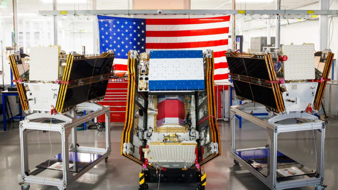
As vast plumes of smoke from hundreds of raging wildfires blanketed parts of Canada and the United States, casting a hazardous pall over major cities and impacting millions, a significant leap forward in wildfire management was achieved. On July 7, 2026, the first three operational satellites of the Google-backed FireSat program successfully rocketed into orbit, marking the initial deployment of a purpose-built constellation designed to provide early and precise wildfire detection. Managed by the nonprofit Earth Fire Alliance, these microsatellites are poised to begin actively providing critical data to fire agencies in the United States, Australia, and Europe before the end of the year, promising to revolutionize the global response to an escalating environmental crisis.
The Dawn of a New Era in Wildfire Detection
The launch from Vandenberg Space Force Base in California, carried aloft by a SpaceX Falcon 9 rocket, signifies the transition to "initial operational capability" for the FireSat constellation. Following a rigorous three-month testing period to ensure optimal performance and data integrity, these pioneering satellites will commence their mission of scanning every fire-prone region on Earth at least twice daily. This regular and high-resolution surveillance capability represents a dramatic improvement over existing systems, which often miss smaller, nascent fires that can rapidly escalate into uncontrollable infernos.
Central to FireSat’s innovative design is its advanced multispectral imaging technology. Each satellite is equipped to peer through dense smoke and heavy cloud cover, a common impediment for conventional satellite systems during major fire events. This sophisticated imaging allows the detection of fires as small as five by five meters – approximately 16 by 16 feet – a resolution previously unattainable for global wildfire monitoring. The efficacy of this technology was conclusively demonstrated by a FireSat Protoflight satellite, which launched in March 2025. During its testing phase, the protoflight unit collected over one million images, successfully identifying low-intensity blazes that were completely invisible to existing satellite networks, proving the concept’s profound potential.
The FireSat program is a testament to the power of collaborative innovation, drawing significant financial and technical support from leading technology giants and philanthropic organizations. Google has committed over $15 million to support the initial deployment and ongoing research, recognizing the critical role of advanced technology in addressing climate resilience. The Bezos Earth Fund has also been a major backer, committing a substantial $26 million to the initiative, underscoring the urgent global need for such a system. The satellites themselves were meticulously designed and manufactured by Muon Space, a California-based satellite firm specializing in advanced Earth observation platforms, bringing their expertise in cutting-edge aerospace engineering to bear on this critical environmental challenge.
A Vision for Global Coverage and Rapid Response

The long-term vision for the FireSat constellation is ambitious and far-reaching. While initial data provision will focus on fire agencies in California, Colorado, Australia, and Portugal – designated as "early adopter" organizations – the program aims for rapid expansion. As more satellites are launched, the Earth Fire Alliance intends to provide the latest imagery from anywhere in the world on an hourly basis by 2029. The ultimate goal, projected for the early 2030s, is to establish a full constellation of more than 50 satellites, enabling a remarkable 20-minute revisit rate for global fire-prone areas. This level of near real-time monitoring would provide an unprecedented advantage to firefighters and emergency responders worldwide.
The potential benefits of such rapid and precise detection are immense and quantifiable. The Earth Fire Alliance has projected that even an hourly revisit rate from the FireSat constellation could lead to substantial reductions in the devastating impacts of wildfires. Their analysis suggests potential savings exceeding $1 billion in fire damage costs annually, preventing the emission of nearly 22 million tons of carbon, and safeguarding approximately 3,500 homes and 1.3 million acres of land from destruction. These projections highlight FireSat not just as a technological marvel, but as a crucial tool in mitigating the socio-economic and environmental toll of wildfires.
The Crucial Role of AI and Collaborative Funding
Google’s involvement extends beyond financial backing. Google Research is deeply integrated into the program, leveraging the company’s formidable artificial intelligence capabilities to enhance FireSat’s effectiveness. AI models will be employed to compare operational FireSat data with historical images, enabling the accurate identification of even the most minute fires and informing sophisticated predictive modeling of wildfire behavior. This AI-driven analysis promises to transform raw satellite data into actionable intelligence, allowing fire agencies to anticipate fire spread and allocate resources more strategically. Google itself lauded the launch of the first operational FireSat satellites as "another tangible step forward in putting practical AI to work for climate resilience," signaling a strategic commitment to deploying its technological prowess in the fight against climate change impacts.
The partnership between a non-profit like the Earth Fire Alliance, a commercial satellite manufacturer like Muon Space, and tech giants such as Google and the Bezos Earth Fund, represents a compelling model for addressing complex global challenges. This multi-sector collaboration allows for the rapid development and deployment of high-cost, high-tech solutions that might otherwise be beyond the scope of any single entity. It underscores a growing recognition that innovative, privately-funded initiatives, when aligned with public good, can play a pivotal role in augmenting governmental efforts and traditional approaches to disaster management.
Wildfires Rage: A Sobering Backdrop to Innovation
The launch of the FireSat satellites occurs against a stark and urgent backdrop of worsening global wildfires. In July 2026, Canada’s boreal forests are experiencing a particularly ferocious wildfire season, generating massive smoke clouds that have traversed national borders. This has forced the evacuation of thousands, including numerous First Nations communities whose traditional lands and ways of life are disproportionately affected. The smothering smoke has drifted across Canadian and US cities, inflicting hazardous air pollution upon more than 100 million people, disrupting daily life, and posing significant health risks.

This current crisis is not an isolated incident but part of a disturbing trend directly linked to climate change. Canada, for example, witnessed its most destructive wildfire seasons in 2023 and 2025, with the last three fire seasons consistently ranking among the ten worst on record. The increasing frequency and intensity of these blazes are precisely what climate and forest scientists have predicted for decades. As Werner Kurz, a retired senior research scientist at Natural Resources Canada, articulated to The Atlantic, "What is unfolding is what climate and forest scientists have been predicting for 30 years… That as the world gets hotter and drier, we are exposing forests to more and more risk, and the old strategies of fire suppression are simply being overwhelmed."
The Canadian Wildland Fire Information System reported nearly 900 active wildfires across the country as of July 17, 2026. To date, Canada has experienced over 3,600 wildfires, scorching more than 6.6 million acres – an area roughly the size of Belgium. Alarmingly, dozens of these are classified as "out of control" wildland fires, meaning they are being monitored rather than actively suppressed. This difficult decision is often a painful necessity for fire agencies, forced to manage limited resources and prioritize the safety of firefighting personnel when faced with overwhelming infernos in remote, largely uninhabited forest regions.
Beyond Detection: The Complexities of Wildfire Management
While FireSat offers a groundbreaking tool for early detection, it is crucial to understand that it represents one, albeit vital, component within the complex ecosystem of wildfire management. Detection alone, no matter how sophisticated, cannot fully prevent or extinguish wildfires without adequate resources for ground-level intervention and ecosystem management. Fire agencies still require sufficient personnel, equipment, and funding to implement prescribed burns – a critical tool for reducing fuel loads and restoring ecological balance – and to actively suppress unwanted fires once they ignite.
The challenges are particularly acute in vast, remote regions like Canada’s boreal forests. Fighting wildfires in these areas demands specialized and costly resources, including fixed-wing air tankers capable of dropping fire retardants over vast distances, and heavy-lift helicopters for water bombing and transporting firefighting crews to inaccessible sites. The burden of acquiring and contracting for such expensive firefighting aircraft typically falls upon individual Canadian provinces, and in recent years, every available asset has been stretched to its limit. Recognizing this strain, the Canadian federal government stepped in this year, leasing 10 new aerial firefighting aircraft to serve as crucial surge assets for provinces facing overwhelming fire seasons, a measure indicative of the scale of the challenge.
The Environmental Footprint of AI: A Paradoxical Challenge
As Silicon Valley champions the deployment of advanced AI models to combat climate change, a critical paradox emerges concerning the environmental footprint of these very technologies. The burgeoning demand for larger and more powerful AI data centers necessitates massive amounts of electricity. This energy demand is increasingly being met by new natural gas projects in the United States, which, according to some analyses, could collectively emit more than 129 million tons of greenhouse gases per year. This potential for increased emissions from AI infrastructure poses a significant challenge, inadvertently exacerbating the very climate crisis that initiatives like FireSat seek to mitigate.

Google itself has openly acknowledged the difficulties of deploying enough clean energy projects to offset the escalating emissions from its energy-hungry data centers. The company’s overall electricity usage, driven by its aggressive AI buildout, reportedly grew by a substantial 37 percent in 2025 alone. This highlights a broader, industry-wide challenge: how to reconcile the immense computational power required for AI development and deployment with the urgent imperative to decarbonize global energy systems. While AI-powered wildfire detection offers a powerful solution, the environmental cost of its underlying infrastructure demands careful consideration and sustained investment in renewable energy sources.
Conclusion: A Critical Tool in a Broader Battle
The launch of the FireSat constellation represents a monumental achievement in the application of space technology and artificial intelligence to a pressing global challenge. Its ability to detect small fires early and provide near real-time data holds the promise of significantly reducing wildfire damage, carbon emissions, and the human toll of these increasingly destructive events. It is a critical new tool for climate resilience, offering a beacon of hope amid the intensifying impacts of a warming planet.
However, FireSat, for all its revolutionary potential, is but one piece of a much larger, intricate puzzle. The global wildfire crisis is a multifaceted problem demanding a holistic approach that extends beyond advanced detection. It necessitates robust investment in proactive forest management, including prescribed burns, adequate resources for fire suppression, and, fundamentally, aggressive global action to reduce greenhouse gas emissions and slow the pace of climate change. As the world grapples with the escalating consequences of a changing climate, FireSat stands as a powerful symbol of innovation, yet also as a stark reminder that technological solutions must be integrated into comprehensive strategies that address the root causes of our environmental challenges. The race between human ingenuity and the accelerating impacts of climate change continues, with the fate of forests, communities, and global air quality hanging in the balance.