In a groundbreaking study that upends conventional meteorological understanding, atmospheric scientists have discovered a long-range climatic bridge connecting abnormally high temperatures on the Tibetan Plateau to devastating rainfall events across California and neighboring western states. Published in a leading climate science journal, the research establishes for the first time a direct climate teleconnection between the Roof of the World and the hydrological disasters that struck the American West during the early months of 2017 and 2023.
This newly identified atmospheric mechanism not only solves a long-standing meteorological puzzle regarding the intensity of these historic storms but also offers a transformative opportunity for predictive forecasting. By recognizing how thermal anomalies thousands of miles away can dictate precipitation extremes on the Pacific Coast, emergency management agencies and meteorological services may soon possess the advanced warning systems necessary to protect vulnerable coastal communities, save lives, and mitigate billions of dollars in infrastructure damage.
The Mechanics of a Global Teleconnection
Climate teleconnections refer to weather anomalies that relate to each other at large distances, typically thousands of kilometers apart. While phenomena such as El Niño and La Niña are well-documented examples influencing global weather patterns, the newly discovered pathway between the Tibetan Plateau and the western United States represents an entirely different class of atmospheric interaction.
The Tibetan Plateau, often referred to as the Third Pole, holds the largest reserve of ice outside the polar regions and exerts a profound influence on the Asian monsoon and global atmospheric circulation. Because of its massive elevation—averaging over 4,500 meters above sea level—the plateau acts as an elevated heat source during the spring and summer months, absorbing solar radiation and warming the troposphere above it.
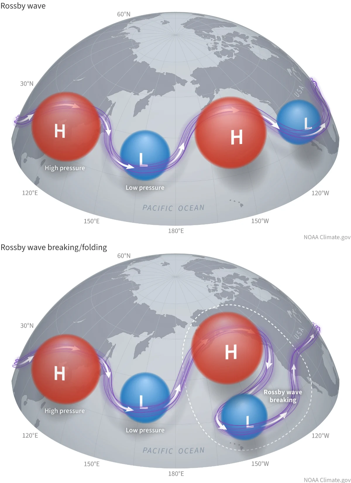
According to the new study, when temperatures on the plateau spike significantly above normal, they trigger a complex chain reaction in atmospheric wave patterns. These thermal anomalies generate planetary-scale Rossby waves—giant ripples in the atmospheric pressure field that meander around the globe. Under specific conditions, these waves propagate eastward across the Eurasian landmass, cross the Pacific Ocean, and amplify existing weather systems right off the coast of North America.
When these amplified waves stall or align with natural moisture conveyors like atmospheric rivers, the results are catastrophic. The study demonstrates that the extreme heat events recorded on the Tibetan Plateau preceded the torrential downpours in California by several weeks, acting as a crucial upstream trigger that primed the Pacific jet stream to deliver relentless waves of moisture to the western U.S.
Chronology of the Disasters: 2017 and 2023
To understand the magnitude of this discovery, researchers analyzed the meteorological conditions surrounding two of the most destructive wet seasons in modern California history: the winters of 2017 and 2023.
The Winter of 2017: Breaking a Historic Drought
The winter of 2017 brought a dramatic and destructive end to California’s historic five-year drought. Beginning in January 2017, a relentless parade of atmospheric rivers slammed into the coast, dumping trillions of gallons of water and feet of snow onto the Sierra Nevada mountain range.
- Early January 2017: Abnormally high temperatures were recorded across the Tibetan Plateau, setting off amplified planetary wave activity that began propagating across the Northern Hemisphere.
- Late January to February 2017: The atmospheric anomalies reached the North Pacific, stabilizing a powerful jet stream pattern that directed successive atmospheric rivers straight into central and northern California.
- February 7–12, 2017: The Oroville Dam crisis unfolded as unprecedented rainfall filled the reservoir to capacity, severely damaging its main and emergency spillways and prompting the emergency evacuation of more than 180,000 residents downstream.
- End of Winter 2017: Statewide precipitation shattered records, causing billions of dollars in agricultural losses, flooded communities, and widespread infrastructural damage, even as it replenished depleted reservoirs.
The Winter of 2023: The Atmospheric River Parade
Six years later, the pattern repeated itself with even greater frequency, resulting in one of the wettest winters in California’s recorded history.
- December 2022: Meteorological sensors across the Tibetan Plateau registered another significant thermal anomaly, with surface temperatures lingering well above seasonal averages.
- Late December 2022 to January 2023: The resulting atmospheric waves synchronized with a persistent high-pressure ridge in the Atlantic and a deep low-pressure trough in the Pacific, creating an open pipeline of moisture from the tropics directly to the U.S. West Coast.
- January 4–15, 2023: A rapid succession of nine distinct atmospheric rivers battered the state. Gusty winds downed millions of trees, saturated soils led to catastrophic mudslides, and urban centers from San Francisco to Los Angeles experienced severe flooding.
- March 2023: Additional late-season storms compounded the damage, bringing the total statewide death toll to over 20 people and causing property damage and economic losses exceeding $5 billion.
Supporting Data and Observational Evidence
The research team utilized decades of reanalysis data, combining satellite observations, high-altitude radiosonde balloon measurements, and advanced computer climate models to trace the physical path of the energy and moisture transfer.
Statistical modeling confirmed a high correlation coefficient between extreme surface temperature anomalies on the Tibetan Plateau and anomalous precipitation indices in California during the late winter months. By isolating variables related to El Niño-Southern Oscillation (ENSO) and the Pacific Decadal Oscillation (PDO), the researchers demonstrated that the Tibetan teleconnection operates independently, explaining severe weather events that standard Pacific-based models often failed to anticipate.
Furthermore, isotopic analysis of water vapor transport during the 2017 and 2023 events revealed unique atmospheric velocity signatures consistent with long-distance wave propagation originating from high-elevation Asian landmasses. These data points provide a robust empirical foundation for what was previously only suspected through theoretical atmospheric physics.
Official Responses and Scientific Implications
The meteorological community has received the findings with a mixture of validation and urgency. Operational forecasting agencies, which have long struggled to provide accurate precipitation outlooks more than a week or two in advance, view the discovery of this teleconnection as a potential game-changer for sub-seasonal to seasonal (S2S) forecasting.
In statements accompanying the release of the study, lead authors emphasized that incorporating Tibetan Plateau thermal metrics into global numerical weather prediction models could significantly extend warning horizons. Currently, emergency planners often have only 7 to 10 days of notice before an intense atmospheric river makes landfall. By monitoring the thermal state of the Tibetan Plateau weeks or even months ahead of time, forecasters could gain an early indicator of heightened western U.S. flood risk.
State and federal water management officials in California have also expressed keen interest in the findings. The California Department of Water Resources noted that better long-range forecasting is vital for managing reservoir levels. Water managers must constantly balance the risk of floods against the need to store water for the dry summer months; knowing that an unusually warm spring or winter on the other side of the globe increases the likelihood of a deluge months later could revolutionize reservoir drawdowns and flood-control operations.
Broader Economic and Societal Impacts
The implications of this research extend far beyond academic curiosity. Extreme weather events fueled by atmospheric rivers are among the costliest natural disasters in the United States.
According to historical loss data, atmospheric rivers are responsible for roughly 80 percent of California’s flood damages and account for billions of dollars in insured and uninsured losses every consecutive decade. Agricultural sectors, transportation networks, real estate markets, and municipal stormwater systems all bear the brunt of these intense meteorological shocks.
By enhancing prediction capabilities through the integration of global teleconnection indices, society can transition from a reactive disaster-response posture to a proactive resilience strategy. Early warnings allow local municipalities to preposition sandbags, clear drainage channels, reinforce levees, and issue timely evacuation orders that minimize loss of life.
Moreover, as global climate change continues to warm high-altitude regions like the Tibetan Plateau at rates significantly faster than the global average, understanding these distant ripple effects becomes increasingly critical. If accelerated warming on the plateau leads to more frequent or intense thermal anomalies, western North America may face an elevated baseline risk of severe hydrological extremes in the decades to come.
Ultimately, this study underscores the profound interconnectedness of Earth’s climate system. It demonstrates that a localized warming event on a remote, windswept plateau in Central Asia can have immediate, tangible, and sometimes devastating consequences for families, farms, and cities along the coast of California—proving once again that in modern meteorology, no weather event happens in isolation.