
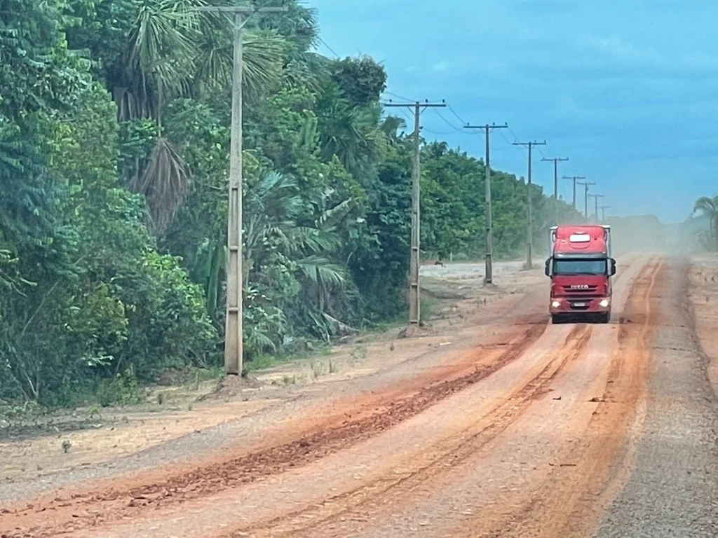
Deep within the sprawling, emerald expanse of the Brazilian Amazon, a new and alarming power dynamic is taking root. According to a comprehensive scientific study recently published in the scientific journal Transportation Research Part D: Transport and Environment, vast tracts of pristine rainforest surrounding the controversial BR-319 highway have fallen under the absolute dominance of criminal syndicates. These illicit networks are tightly woven into a web of illegal logging, wildcat gold mining, systematic land grabbing, and industrial-scale cattle ranching. The findings arrive at a precarious political and environmental crossroads, as the federal government under President Luiz Inácio Lula da Silva pushes forward with plans to upgrade and pave the long-neglected infrastructure project—a move that conservation scientists warn could push the world’s largest tropical rainforest past an irreversible ecological tipping point.
The BR-319 highway, which spans roughly 885 kilometers (550 miles) and connects the isolated northern Amazonian capital of Manaus to Porto Velho in Rondônia, has long been a focal point of Brazil’s developmental ambitions and conservation anxieties. Originally constructed in the 1970s during the height of the nation’s military dictatorship, the thoroughfare was designed to integrate the remote northern territories with the rest of the country. However, due to prohibitive maintenance costs, intense seasonal heavy rainfall, and shifting national priorities, the highway fell into profound disrepair by the late 1990s. For over two decades, its infamous 339-kilometer (211-mile) middle section remained largely impassable for conventional traffic during the rainy season, acting as a formidable natural barrier that inadvertently protected one of the most intact and biodiverse forest corridors in the Amazon basin.
The Anatomy of a Lawless Frontier
The modern crisis enveloping the BR-319 corridor did not materialize overnight; rather, it is the cumulative result of decades of shifting political will, inadequate state surveillance, and escalating speculative pressure. Research led by Lucas Ferrante, a prominent ecologist and conservation biologist associated with São Paulo University (USP) and the Center for Research on Biodiversity and Climate Change (CBioClima), meticulously tracked the catastrophic acceleration of deforestation in the region. According to the study, land clearance surged exponentially following 2015, when then-President Dilma Rousseff authorized the first tentative maintenance works on the abandoned route.
The situation deteriorated further under Rousseff’s successor, right-wing populist Jair Bolsonaro. Bolsonaro made vocal, unyielding promises to fully pave the highway, an announcement that acted as an immediate green light for land speculators, wildcat prospectors, and illegal loggers. These actors rushed to stake claims along the route, systematically converting dense primary forest into temporary cattle pastures to establish fraudulent land titles—a process locally known as grilagem.
In interviews detailing the research, Ferrante emphasized that the absence of a permanent, robust state presence transformed the region into a fertile breeding ground for organized crime. Far from operating as isolated infractions, environmental crimes along the BR-319 are now deeply integrated with transnational illicit economies.
"This region is becoming a hub of large farms controlled by organized crime," Ferrante stated during a video interview discussing the research methodology and field observations.
According to the study’s findings, drug trafficking organizations frequently utilize the same clandestine logistics networks, riverways, and financial channels as illegal loggers and miners. Furthermore, extensive cattle ranching operations function as sophisticated mechanisms for money laundering, allowing criminal organizations to legitimize capital derived from narcotics, illegal gold extraction, and timber smuggling by funneling it through legal agricultural markets.
Methodology and Grim Realities on the Ground
To arrive at these stark conclusions, the research team adopted a multifaceted investigative approach. The study combined rigorous geospatial analysis of satellite imagery, official deforestation tracking data, extensive cattle trading and transit documents, and five rigorous field expeditions conducted directly within the contested zones.
These expeditions brought researchers face-to-face with the violent human cost of unchecked land speculation. During one field survey along an unauthorized side road branching off the main highway, Ferrante and his team made a grim discovery: the dead body of a local farm worker, discarded in the brush. The incident underscored the escalating lethality of land conflicts in the region, where rural workers, indigenous populations, and traditional communities face constant intimidation, displacement, and violence from armed actors working on behalf of criminal land grabbers.
The proliferation of secondary access roads—unofficial tracks bulldozed into the forest by land grabbers and loggers—far outstrips the capacity of current government control mechanisms. Ferrante noted that the total length of these illegal side roads is already six times greater than the length of the BR-319 highway itself. This vast network of unmonitored arteries allows criminal syndicates to extract timber, smuggle gold, and move contraband deep from the forest interior out to regional markets without encountering law enforcement.

Chronology of Policy Shifts and Political Maneuvering
The political timeline surrounding the BR-319 reflects a tense tug-of-war between developmental pressures and environmental imperatives:
- 1970s: The military dictatorship constructs the BR-319 highway to integrate Manaus with Porto Velho and the southern regions of Brazil.
- 1998: Due to high maintenance costs and severe environmental degradation, the road is largely abandoned, falling into severe disrepair and returning large sections of the surrounding forest to isolation.
- 2015: President Dilma Rousseff authorizes initial maintenance work on the highway, sparking the first wave of renewed land speculation and a sharp uptick in localized deforestation.
- 2018–2022: Under President Jair Bolsonaro, the administration aggressively champions the full paving of the highway, fueling widespread illegal land grabbing, cattle ranching expansion, and environmental deregulation.
- April 2026: President Luiz Inácio Lula da Silva’s administration moves to advance infrastructure work on the BR-319, utilizing a novel legal loophole to bypass traditional, rigorous environmental licensing requirements. Conservationists immediately sound alarms, warning of an impending ecological tipping point.
- May 2026: Environmental studies and government proposals project significant spending—including initial allocations of approximately 1.5 billion Brazilian reals—to fund both highway improvements and a massive environmental control zone.
- September 2026: In a bid to mitigate upcoming ecological fallout, the Lula administration officially establishes four new sustainable development reserves spanning roughly 668,000 hectares (1.65 million acres) adjacent to the BR-319 corridor.
- Late 2026: The published study by Ferrante et al. details the total dominance of organized crime over the corridor, challenging the government’s mitigation strategies and calling for the immediate revocation of road-paving licenses.
The Government’s Mitigation Strategy vs. Scientific Skepticism
Faced with mounting national and international pressure regarding the ecological consequences of modernizing the BR-319, the administration of President Lula da Silva has attempted to strike a delicate balance between regional economic integration and environmental stewardship. Proponents of the paving project argue that an all-weather road is essential for supplying the millions of residents in Manaus, reducing freight costs, and integrating isolated northern populations into the national economy.
To counter criticisms that the project will trigger an unmitigated wave of deforestation, the federal government enacted a series of defensive measures throughout 2026. In September, the administration established four new sustainable development reserves covering a combined area of 668,000 hectares (1.65 million acres) near the highway corridor, intended to create a legal buffer against further encroachment. Additionally, federal infrastructure plans outline the construction of three major surveillance checkpoints and approximately 170 specialized fauna crossings designed to ensure safe passage for local wildlife populations traversing the fragmented landscape.
However, environmental scientists and security analysts argue that these bureaucratic and physical safeguards are profoundly inadequate when matched against the sheer scale of the crisis. Ferrante’s research highlights a massive logistical shortfall in the government’s enforcement strategy. While federal officials have proposed a handful of checkpoints, Ferrante calculates that at least 28 fully staffed federal checkpoints would be required—stationed continuously to inspect vehicles for illegal cargo on every single secondary and tertiary road branching off the BR-319—to exert even a basic level of control over the territory. Given that the network of illegal access roads now dwarfs the main highway by a factor of six, critics contend that the state lacks the logistical footprint, financial resources, and political clout to police the region effectively.
Broader Environmental Implications and the Tipping Point
The stakes surrounding the BR-319 extend far beyond local law enforcement and regional land disputes; they represent a critical juncture for the global climate system. The Amazon rainforest plays an irreplaceable role in regulating global weather patterns, sequestering vast quantities of atmospheric carbon, and driving the South American hydrological cycle through the generation of "flying rivers"—massive atmospheric moisture currents that supply rainfall to agricultural heartlands across the continent.
Climatologists and environmental scientists have repeatedly warned that the Amazon is rapidly approaching a dangerous "tipping point." If deforestation, fragmentation, and climate-induced warming surpass a critical threshold—estimated by some researchers to lie between 20% and 25% of total forest loss—large portions of the eastern, southern, and central Amazon could undergo a rapid, irreversible transition into a degraded savanna-like ecosystem. Such a collapse would release billions of metric tons of stored carbon back into the atmosphere, critically undermining international efforts to combat global climate change.
The authors of the new study do not mince words regarding the catastrophic trajectory of the current policy path. In their concluding recommendations, they urge federal authorities to immediately reassess, suspend, or outright revoke the environmental licenses and regulatory mechanisms that currently permit further road improvement and paving operations.
"Under current governance conditions, paving BR-319 would consolidate a high-risk corridor for environmental crime, territorial appropriation, public insecurity, and potentially irreversible socio-environmental degradation," the study explicitly warns.
As Brazil navigates the complex demands of economic modernization, regional equity, and planetary preservation, the fate of the BR-319 corridor serves as a sobering test case. Whether the federal government can reclaim a territory currently governed by the iron fist of organized crime—or whether the asphalt will ultimately seal the doom of one of Earth’s greatest ecological treasures—remains one of the most pressing and consequential questions of modern environmental politics.