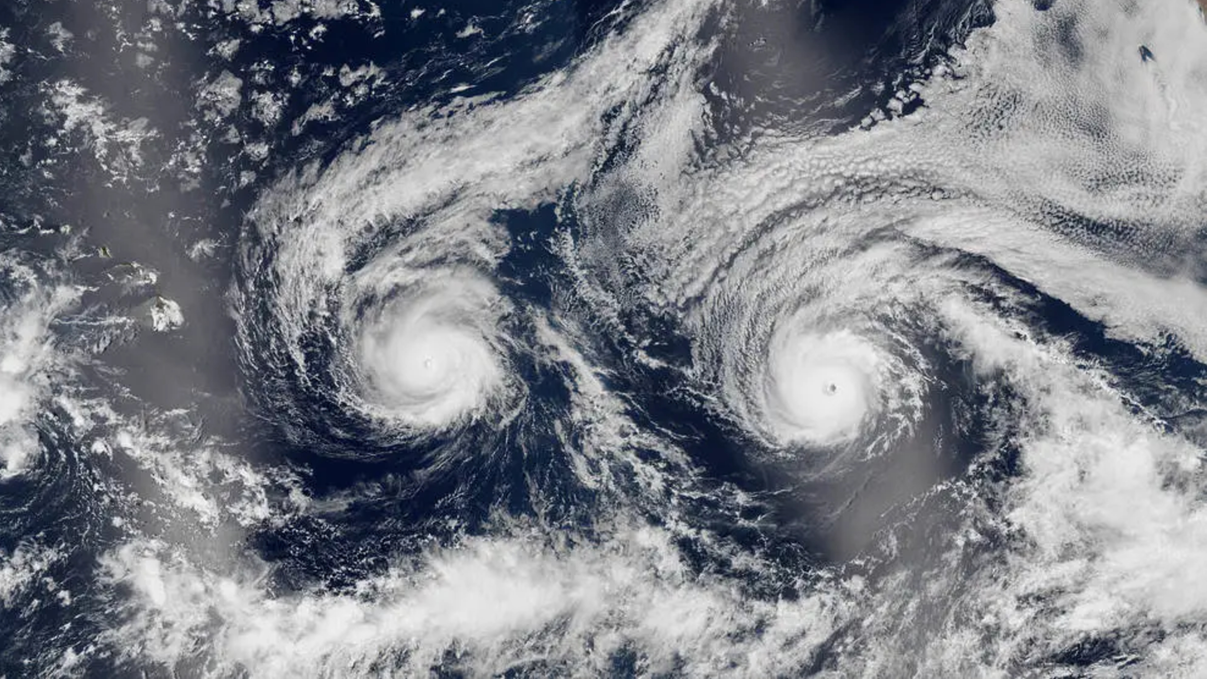
Captured from the vantage point of Earth orbit on August 29, 2016, a remarkable and somewhat surreal satellite image revealed two powerful tropical cyclones swirling side-by-side in the Pacific Ocean. Known individually as Hurricane Madeline and Hurricane Lester, this dynamic duo formed a striking meteorological coincidence that collectively resembled a giant, glowing smiley face when viewed from space. While the visual spectacle captured the imaginations of observers around the globe, the underlying meteorological event was a serious and high-stakes situation for the residents of Hawaii, who braced themselves for potential dual landfalls just as the peak of the Pacific hurricane season was unfolding.
The image, acquired by the NASA/Suomi NPP satellite using its advanced Visible Infrared Imaging Radiometer Suite (VIIRS), highlighted the intricate cloud structures of both storms. On the left side of the frame, Hurricane Madeline swirled counterclockwise, its distinct eye positioned just off the coast of Hawaii’s Big Island. On the right, Hurricane Lester mirrored its companion, displaying a massive, well-defined envelope of spiraling clouds. In a quirk of orbital geometry and atmospheric lighting, a brilliant patch of sunglint—the mirror-like reflection of the sun off the ocean surface—obscured parts of the ocean and the Big Island on the left side of the image, unintentionally creating what appeared to be the glowing eyes and upturned mouth of a celestial emoji looking down at Earth.
Chronology of a Double Threat
The late-August 2016 Pacific hurricane season was exceptionally active, driven in part by favorable oceanic temperatures and atmospheric conditions conducive to tropical cyclogenesis. The sequence of events leading up to the iconic satellite capture began weeks prior, but the critical window of threat compressed rapidly in the final days of August.
By late August, both Madeline and Lester had strengthened into formidable hurricanes while traversing the warm waters of the central and eastern Pacific. Hurricane Madeline formed first from a tropical depression, steadily intensifying as it tracked west-northwestward toward the Hawaiian Islands. By August 26 and 27, Madeline had reached major hurricane status, peaking as a Category 4 storm with maximum sustained winds reaching near 130 miles per hour.
As Madeline churned closer to the Hawaiian archipelago, Hurricane Lester was hot on its heels. Lester had also attained major hurricane strength, packing sustained winds of up to 140 miles per hour as it traveled across the open Pacific on a similar westerly trajectory. The simultaneous presence of two Category 4-equivalent hurricanes in close geographic proximity to a major island chain is a rare and perilous meteorological scenario, putting emergency management officials on high alert.
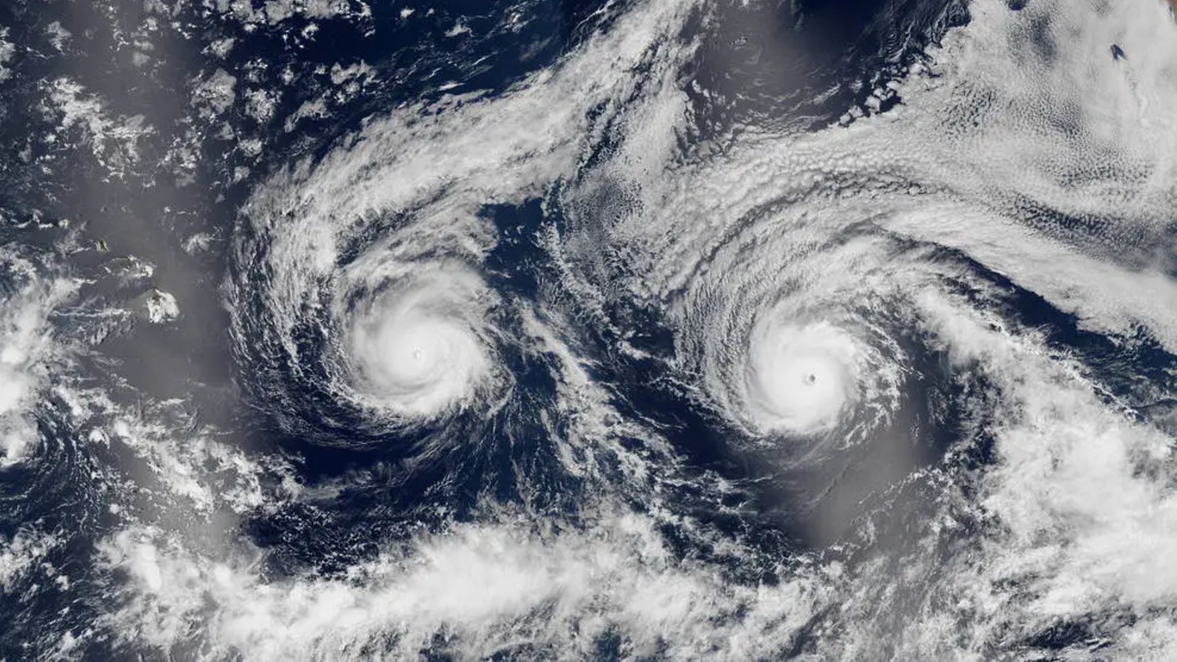
On August 29, 2016, as the Suomi NPP satellite passed overhead, the atmospheric alignment of the two storm systems created the memorable visual phenomenon. However, the levity of the "smiley face" cloud formation contrasted sharply with the gravity of the situation on the ground, where communities across the Hawaiian Islands were preparing for potential catastrophic impacts, heavy rainfall, and destructive storm surges.
Meteorological Data and Satellite Technology
The capability to capture such detailed imagery of concurrent tropical systems relies heavily on advanced Earth-observation satellites like the Suomi National Polar-orbiting Partnership (Suomi NPP) spacecraft. Launched in October 2011 as a joint mission between NASA and the National Oceanic and Atmospheric Administration (NOAA), Suomi NPP serves as a critical bridge between legacy weather satellites and modern environmental monitoring platforms.
The instrument responsible for the iconic Madeline and Lester image, the VIIRS sensor, captures high-resolution imagery in both daylight and nighttime conditions. Its Day/Night Band (DNB) is particularly sensitive, capable of detecting low-light signals such as city lights, auroras, and moonlight-illuminated cloud tops. During daylight passes, VIIRS provides crisp, true-color imagery that allows meteorologists and researchers to analyze eye structures, cloud-top temperatures, rainbands, and outer wind fields with unprecedented precision.
Data collected during the August 2016 event provided critical insights into how dual hurricanes interact—a phenomenon often studied through the lens of the Fujiwhara effect, where two nearby cyclonic vortices orbit one another or interact destructively and constructively. While Madeline and Lester remained sufficiently separated to maintain their individual structures, their simultaneous presence underscored the complex dynamics of central Pacific weather patterns, which are heavily influenced by cyclical climate drivers such as El Niño and La Niña.
Official Responses and Emergency Preparedness
As Hurricanes Madeline and Lester approached the Hawaiian Islands in late August 2016, federal, state, and local emergency management agencies mobilized comprehensive response plans. The Central Pacific Hurricane Center (CPHC), based in Honolulu, issued continuous advisories, hurricane watches, and tropical storm warnings for the Big Island, Maui County, and eventually Oahu as the tracks of the storms evolved.
Then-Governor of Hawaii David Ige signed an emergency proclamation ahead of Madeline’s expected approach, freeing up state resources, authorizing the mobilization of the Hawaii National Guard, and urging residents to finalize emergency kits and evacuation plans. Shelters were opened across the Big Island, and public schools and non-essential government offices suspended operations to minimize transit risks.
Emergency officials faced unique logistical challenges due to the dual-threat nature of the storms. While Hurricane Madeline was projected to pass uncomfortably close to or directly over the Big Island, Hurricane Lester was forecasted to follow a similar path just days behind, threatening regions that might already be recovering from Madeline’s initial onslaught. The dual-storm scenario stretched local resources thin, requiring heightened coordination between county mayors, the Federal Emergency Management Agency (FEMA), and utility providers to prepare for widespread power outages, flash flooding, and landslides.
Impacts, Dissipation, and Broader Implications
Despite the high level of concern and rigorous preparation, the actual impacts of Hurricanes Madeline and Lester ultimately spared Hawaii the worst-case scenarios, largely due to unfavorable environmental conditions that caused both storms to weaken significantly before making direct landfall.
Hurricane Madeline was the first to test the resilience of the islands. As the storm approached the Big Island on August 31 and September 1, 2016, it encountered increasing vertical wind shear and cooler ocean waters. These inhibiting factors stripped the hurricane of its core strength, downgrading Madeline to a tropical storm before its center passed south of the Big Island. Nevertheless, Madeline delivered substantial rainfall, triggering flash flood warnings, minor property damage, and localized power outages, particularly in the Puna and Kaʻū districts.
Shortly thereafter, attention turned to Hurricane Lester. Forecasted to track dangerously close to Oahu and the rest of the island chain over the Labor Day weekend, Lester also succumbed to hostile atmospheric conditions and cooler sea surface temperatures. By the time Lester passed north of the Hawaiian Islands in early September, it had weakened to a tropical storm. While it generated high surf, coastal erosion, and gusty winds along windward coasts, it ultimately bypassed the islands without inflicting major structural damage or loss of life.
The 2016 close call involving Madeline and Lester left a lasting imprint on Pacific meteorology and disaster management. The event underscored the growing importance of advanced satellite infrastructure—exemplified by Suomi NPP and NOAA’s GOES constellation—in providing early, high-resolution tracking data that enables timely evacuations and precise resource allocation. Furthermore, the episode served as a vivid reminder of the vulnerability of island ecosystems and infrastructure to tropical cyclone activity, prompting ongoing evaluations of community resilience, building codes, and emergency communication strategies in an era of shifting global climate patterns.