
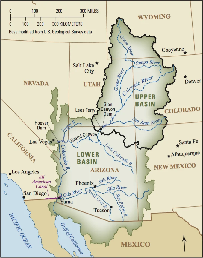
The American West is confronting a sobering hydrological reality as new scientific findings challenge long-held assumptions about regional resilience to arid conditions. A comprehensive analysis of groundwater reserves within the sprawling Colorado River Basin indicates that western states previously considered well-insulated against prolonged drought are actually far more vulnerable than previously understood. The research, which centers on the intense southwestern drought gripping the nation from 2020 through 2022, highlights a troubling disparity in how subterranean aquifers are responding to climatic stress.
According to the study, the four states comprising the Upper Basin—Colorado, New Mexico, Utah, and Wyoming—suffered groundwater losses nearly twice as severe as those recorded in the Lower Basin during the same two-year monitoring window. This revelation has taken hydrologists and geoscientists by surprise. For decades, traditional water management frameworks and scientific models regarded the Upper Basin as a relatively stable hydrological buffer, largely due to its higher elevation, colder climate, and greater accumulation of winter snowpack. However, the new data suggests that these northern reaches are experiencing accelerated subsurface drainage, potentially marking a historic turning point for the entire seven-state river system.
Background and Context of the Colorado River Crisis
The Colorado River is the absolute lifeblood of the American Southwest, supplying municipal drinking water, agricultural irrigation, and hydroelectric power to roughly 40 million people across seven U.S. states and parts of Mexico. Spanning over 1,450 miles from the Rocky Mountains to the Gulf of California, the river’s watershed is legally divided into two distinct administrative zones by the landmark 1922 Colorado River Compact: the Upper Basin and the Lower Basin, demarcated by Lee Ferry, a monitoring point in northern Arizona.
For over two decades, the entire basin has been locked in what climatologists classify as a megadrought—the worst dry spell the region has experienced in at least 1,200 years. Driven by rising global temperatures, diminishing winter snowpacks, and persistently below-average precipitation, surface reservoirs such as Lake Mead and Lake Powell have plummeted to historic lows, triggering mandatory federal water cuts and tense interstate negotiations.
Historically, water management policies, public anxieties, and scientific studies focused predominantly on the Lower Basin—specifically Arizona, Nevada, and California—where massive desert municipalities like Phoenix and Las Vegas, alongside sprawling desert agriculture, place immense demands on surface water. Because the Upper Basin states receive significantly more snow and experience cooler temperatures, policymakers operated under the assumption that subterranean aquifers in Colorado, New Mexico, Utah, and Wyoming would remain relatively buffered against surface-level drying trends. The latest findings systematically dismantle that comforting premise.
Chronology of the 2020–2022 Drought Shock
To understand how rapidly subsurface conditions deteriorated, researchers focused closely on the acute meteorological and hydrological events that unfolded between 2020 and 2022.
- Early 2020: La Niña climate patterns began to settle over the Pacific, setting the stage for below-average winter precipitation across the western United States. Soil moisture levels across the Rocky Mountains and the Colorado Plateau dropped precipitously following a weak snowpack year.
- Summer 2020: Extreme heatwaves baked the entire western corridor, causing historic rates of evaporation. Agricultural water users in the Upper Basin began pumping groundwater at accelerated rates to compensate for dwindling surface irrigation deliveries.
- Water Year 2021: Widely recognized by hydrologists as one of the most anomalous years on record, 2021 saw near-normal winter snowfall in parts of the Upper Basin, yet spring runoff failed to materialize in expected volumes. Unusually dry, warm soils acted like a massive sponge, absorbing the melting snow before it could recharge streams or percolate down into regional aquifers.
- 2022: As the megadrought intensified into its most punishing phase, satellite observations and ground-based monitoring confirmed an unprecedented subsurface deficit. It was during this period that geoscientists tracking Gravity Recovery and Climate Experiment (GRACE) satellite data noticed the stark divergence: Upper Basin groundwater depletion was occurring at nearly double the rate of the Lower Basin.
Quantitative Analysis and Supporting Data
Led by researchers at Virginia Tech, including doctoral student in geosciences and lead author Esther Oyedele, the study utilized advanced remote sensing technology and hydrological modeling to quantify changes in total water storage. By analyzing data collected by NASA’s twin GRACE satellites—which measure minute shifts in Earth’s gravitational field caused by changes in mass, including underground water—the team was able to map water table fluctuations with remarkable precision.
The data revealed that while Lower Basin states experienced significant surface water stress, their management of subterranean storage and localized geology allowed them to retain a larger proportion of their baseline groundwater reserves during the 2020–2022 window. Conversely, Upper Basin states experienced accelerated aquifer drawdown.
Hydrologists attribute this discrepancy to several compounding factors. First, the porous geological formations characteristic of large portions of the Upper Basin allow for rapid drainage when overlying soils dry out. Second, as surface water allocations from rivers and streams were curtailed or proved insufficient, farmers and municipalities in Colorado, New Mexico, Utah, and Wyoming turned increasingly to groundwater pumping to bridge the deficit. Without adequate recharge from snowmelt, these subterranean reservoirs were rapidly mined faster than natural hydrological cycles could replenish them.
Scientific Implications and Expert Perspectives
The realization that the Upper Basin is highly susceptible to prolonged drought carries profound implications for the legal, political, and ecological future of the American West.
For nearly a century, interstate water law has operated on the premise that the Upper Basin would consistently deliver scheduled volumes of water downstream to the Lower Basin, regardless of climatic fluctuations. However, if the northern states are themselves losing groundwater reserves at an alarming rate, their long-term ability to meet these interstate delivery obligations comes into serious question.
Geoscientists emphasize that groundwater acts as the ultimate safety net during surface droughts. When rivers run low and reservoirs empty, communities and agricultural producers drop wells deeper into the earth to sustain operations. When these deep aquifers are depleted, the safety net disappears entirely, increasing the risk of sudden agricultural collapse, land subsidence, and irreversible ecological damage to riparian habitats.
Furthermore, scientists point out that subsurface depletion in mountainous and high-plateau regions alters baseflow—the underground water that feeds streams and rivers during dry summer months. If groundwater tables continue to drop, rivers like the Colorado, Green, and Gunnison will experience even lower baseflows, exacerbating the crisis for aquatic ecosystems and downstream water users alike.
Looking Ahead: The Need for Adaptive Management
As federal agencies, state water commissioners, and academic researchers digest these findings, pressure is mounting to fundamentally rewrite how the West monitors and manages its water resources. Traditional planning models that rely on historical weather data from the 20th century are no longer viable in the face of rapid aridification and shifting hydrological baselines.
Experts stress the urgent need for integrated water management strategies that treat surface water and groundwater as a single, unified resource rather than separate entities. Enhanced monitoring networks, stricter regulation of agricultural well drilling, and substantial investments in artificial recharge projects are viewed as vital steps toward stabilizing the basin’s subterranean storage.
Ultimately, the revelation that the Upper Basin is not immune to the severe impacts of prolonged drought serves as a stark warning for the entire North American continent. As the impacts of climate change continue to accelerate, the margin for error in the Colorado River Basin has narrowed to virtually zero, demanding unprecedented cooperation and scientific vigilance from all states that share its diminishing waters.






Leave a Reply