
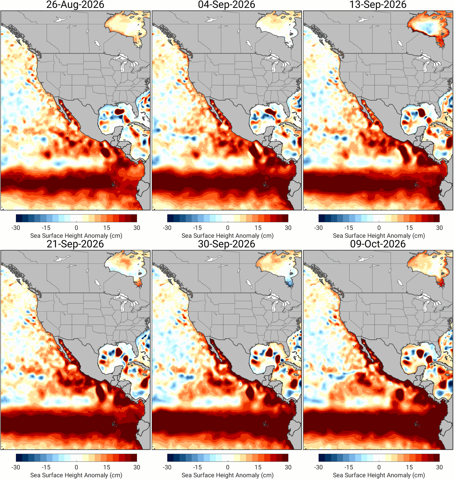
A massive planetary-scale ocean phenomenon known as a Kelvin wave is currently traversing the Pacific Ocean, creeping up the western coast of Central and North America toward the shores of California. Driven by the exceptionally powerful super El Niño conditions developing across the equatorial Pacific, this oceanic disturbance is projected to arrive along the California coastline in the coming weeks. Researchers and oceanographers warn that the wave has the potential to elevate local sea levels by up to one foot (30 centimeters) and sustain these elevated water levels for several consecutive months. While Kelvin waves are a naturally occurring and well-documented component of oceanographic cycles, this specific event has triggered heightened concern among disaster preparedness experts. The temporary yet substantial rise in sea level is expected to act as a force multiplier, significantly amplifying the destructive impacts of severe winter storms, coastal storm surges, extreme high tides, and rapid coastal erosion throughout the upcoming winter season.
Understanding Kelvin Waves and the El Niño Connection
To comprehend the mechanics of this unfolding coastal threat, it is essential to examine the underlying ocean-atmosphere dynamics. A Kelvin wave is not a typical wind-driven surface wave found crashing against a beach. Instead, it is a massive, subsurface undulation of warm water that spans thousands of kilometers horizontally and hundreds of meters vertically. These waves propagate eastward along the equator, driven by shifts in trade winds, before deflecting poleward upon encountering continental landmasses.
In normal years, trade winds blow predominantly from east to west across the tropical Pacific, piling up warm surface water near Indonesia and leaving cooler water exposed off the coast of South America. However, during an El Niño event, these trade winds weaken or, in some cases, reverse direction entirely. This disruption causes vast pools of accumulated warm water in the western Pacific to slosh eastward back toward the Americas. As this warm water shifts, it depresses the thermocline—the boundary layer separating warm surface water from the cold deep ocean—generating powerful downwelling Kelvin waves that travel across the ocean basin.
The current super El Niño event has displayed intensity metrics comparable to some of the strongest historic episodes on record, such as the catastrophic El Niño winters of 1982–1983 and 1997–1998. Because the atmospheric and oceanic engines driving the current cycle are exceptionally robust, the Kelvin waves spawned in the central Pacific are carrying immense thermal energy and volume. As these subsurface warm-water masses reach the North American coastline, they compress coastal waters, reduce upwelling, and physically elevate the sea surface height well above normal astronomical tide predictions.
Timeline and Progression of the Oceanic Disturbance
The lifecycle of this specific oceanic event began months prior in the central and western equatorial Pacific, where anomalous atmospheric conditions first set the stage for a major El Niño. By mid-summer, persistent westerly wind bursts—sudden reversals of the typical atmospheric flow—transferred substantial momentum into the upper ocean layers, acting as the primary trigger for the formation of a deep Kelvin wave.
As late summer transitioned into autumn, oceanographic monitoring systems, including the Tropical Atmosphere Ocean (TAO) array of moored buoys, satellite altimetry data from platforms like Sentinel-6, and subsurface Argo floats, tracked the eastward migration of the warm-water anomaly. By October, the leading edge of the Kelvin wave had crossed the central Pacific, deepening the warm layer and raising sea surface heights across the eastern basin near South America and Central America.
Over the course of November and into December, the wave has continued its relentless northward journey, hugging the continental shelf of Central America and Mexico. Oceanographers tracking the anomaly note that its arrival off the coast of Southern California is imminent. Unlike wind waves that pass in a matter of hours, or storm surges that last for days, a Kelvin wave-induced sea level anomaly is a persistent feature. Once the wave arrives, it establishes a baseline elevation that can persist for three to six months, maintaining higher-than-average water levels throughout the peak of the winter storm season.
Supporting Data and Historical Precedents
The quantitative projections associated with this incoming Kelvin wave are drawn from robust numerical ocean circulation models and historical analogs. Data from the National Oceanic and Atmospheric Administration (NOAA) and academic institutions monitoring coastal sea levels indicate that temporary sea level anomalies driven by strong El Niño Kelvin waves typically range from 6 to 12 inches (15 to 30 centimeters) along the U.S. West Coast.
While an extra foot of water may appear modest in deep ocean environments, its impact in shallow coastal zones is magnified exponentially. According to standard coastal engineering calculations, for every single inch of sea level rise, the shoreline can experience several feet of horizontal retreat under wave action. When combined with high astronomical tides—often referred to colloquially as "king tides"—even a moderate storm can breach seawalls, flood low-lying coastal neighborhoods, and inundate critical infrastructure such as Pacific Coast Highway corridors, coastal wastewater treatment facilities, and low-lying beachfront communities from San Diego to Crescent City.
Historical precedent underscores the validity of these concerns. During the severe 1997–1998 El Niño winter, a comparable combination of strong Kelvin wave activity, elevated baseline sea levels, and intense atmospheric storms battered the California coast. That season resulted in hundreds of millions of dollars in infrastructure damage, unprecedented cliff collapses in residential areas like San Francisco’s Pacifica and various points in Orange County, and severe flooding in coastal river valleys. The 1982–1983 event similarly caught coastal communities off-guard, causing widespread destruction to piers, coastal railways, and residential properties.
Official Responses, Warnings, and Mitigation Efforts
In response to advanced modeling data, federal, state, and local emergency management agencies have initiated proactive outreach and preparedness campaigns. NOAA’s Climate Prediction Center, alongside the National Weather Service, has issued extensive briefings to municipal leaders, port authorities, and emergency response coordinators along the West Coast.
Local governments in vulnerable coastal counties—including San Diego, Orange, Los Angeles, Ventura, Santa Barbara, San Luis Obispo, Monterey, San Francisco, and Humboldt—have begun reviewing and updating emergency action plans. Municipalities are mobilizing resources to reinforce vulnerable shorelines, clear storm drains of debris to mitigate urban flooding, and stockpile sandbags for distribution to residents and business owners whose properties sit in low-lying hazard zones.
Emergency management officials emphasize that the primary danger lies in the compounding nature of the hazards. A coastal storm that might ordinarily produce manageable surf and minor tidal overflow can become highly destructive when riding on top of a permanent one-foot boost in baseline water levels. Consequently, public safety messaging stresses the importance of monitoring daily tide forecasts, heeding local evacuation warnings during peak storm events, and avoiding coastal cliffs that have been weakened by prolonged saturation and wave action.
Broader Environmental, Economic, and Social Implications
Beyond the immediate threat to physical property and infrastructure, the convergence of a super El Niño and a major Kelvin wave carries significant broader implications for marine ecosystems, the regional economy, and long-term climate resilience.
Marine ecosystems along the California coast are acutely sensitive to the arrival of warm-water anomalies. The deepening of the thermocline and the influx of warm, nutrient-poor water brought by the Kelvin wave suppress coastal upwelling—the process that normally pulls cold, nutrient-rich water from the deep ocean up to the surface. This nutrient deprivation can drastically reduce primary productivity, starving phytoplankton populations and cascading up the marine food web. Consequently, commercial fisheries, kelp forests, marine mammal populations, and seabirds often experience significant stress, mirroring ecological disruptions documented during previous major El Niño events.
Economically, the threat to infrastructure poses a direct challenge to the commercial viability of California’s vast coastal economy. Ports, shipping hubs, real estate markets, tourism, and coastal transportation arteries are all vulnerable to prolonged inundation and erosion. The cost of emergency repairs, beach nourishment projects, and long-term coastal adaptation strategies runs into the billions of dollars, placing a heavy fiscal burden on state and local governments.
From a policy perspective, the unfolding event serves as a stark preview of future coastal vulnerabilities. As global sea levels continue to rise due to climate change, events like the current super El Niño-driven Kelvin wave provide a glimpse into what everyday high tides may look like in the decades to come. Scientists and urban planners are increasingly utilizing these extreme natural events as stress tests to evaluate the resilience of coastal defenses and accelerate investments in nature-based solutions, managed retreat, and resilient infrastructure design.
As the Kelvin wave makes its final push up the North American coastline this winter, scientists will continue to monitor its progression using satellite telemetry, ocean buoys, and coastal tide gauges. While the natural rhythm of the Pacific Ocean dictates these powerful oscillations, human communities along the shore must brace for the heightened risks that accompany them, balancing immediate emergency response with long-term adaptation strategies for an increasingly volatile climate.









Leave a Reply