
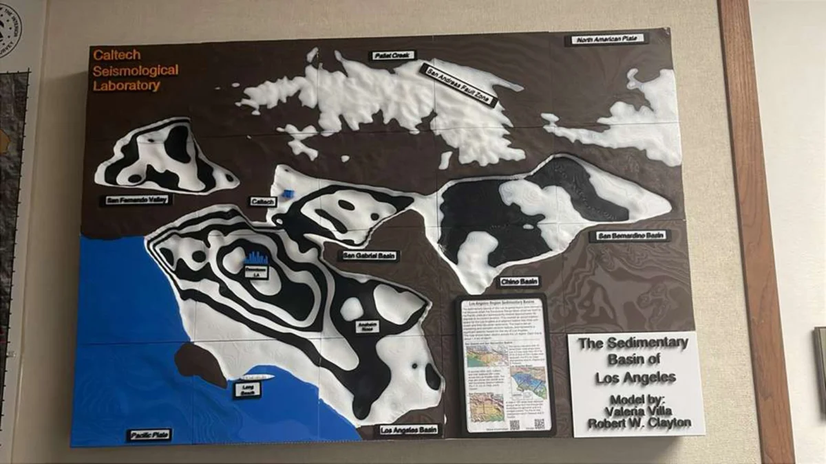
Scientists have unveiled a groundbreaking, highly detailed three-dimensional geological model of the ground beneath the Los Angeles basin, offering unprecedented insight into the subterranean architecture of one of the world’s most populous metropolitan areas. The newly refined map reveals that downtown Los Angeles is underpinned by up to 6.2 miles (10 kilometers) of dense sedimentary deposits. While seismologists have long known that the region sits atop a deep sedimentary basin, this advanced imaging provides a level of precision previously unattainable, painting a clearer and more concerning picture of how the ground is likely to behave during a major seismic event.
The implications of the model extend directly to public safety, urban planning, and civil engineering across Southern California. By mapping the undulating topography of the bedrock beneath the layers of sand, silt, and clay, researchers can now simulate seismic wave propagation with exceptional accuracy. These simulations indicate that the thick sediment bowl beneath downtown Los Angeles and surrounding neighborhoods will act as a resonance chamber, capturing, trapping, and significantly amplifying the shaking intensity of future earthquakes.
The Science of Basin Effects and Seismic Amplification
To understand the gravity of the new findings, it is essential to examine the geological makeup of the Los Angeles basin. Unlike regions built directly on hard, crystalline bedrock—where seismic waves pass through relatively quickly with predictable attenuation—basins filled with thick, soft sediment present a distinct hazard.
When an earthquake occurs along one of the region’s numerous active fault lines, seismic waves radiate outward in all directions. As these energy waves travel from the stiff, deep-seated rock into the softer, shallower sediment of the Los Angeles basin, a complex physical phenomenon occurs. The waves slow down significantly due to the change in material density, but their amplitude increases. Furthermore, because the basin is shaped roughly like a giant, irregular bowl, seismic waves can become trapped inside, bouncing back and forth between the deep bedrock edges and the surface.
This trapping and bouncing effect leads to prolonged shaking durations. While a solid rock foundation might experience a few sharp, intense jolts before the energy dissipates, a deep sedimentary basin can reverberate for minutes after the initial rupture. This extended shaking increases structural fatigue on high-rise buildings, bridges, and infrastructure, raising the potential for catastrophic damage even at distances far removed from the actual fault epicenter.
The newly developed 3D model allows researchers to visualize the subterranean topography of this bowl in unprecedented detail. It maps not only the maximum depth of 6.2 miles beneath the downtown core but also the varying thicknesses of sediment across the entire basin, identifying localized pockets where wave amplification could be exponentially higher.
Chronology of Seismic Mapping in Southern California
The creation of this advanced 3D model represents the culmination of decades of geophysical research, technological advancement, and collaborative data collection in Southern California.
Historically, our understanding of the Los Angeles subsurface was derived from sparse geological core samples, water well logs, and early seismic refraction surveys conducted in the mid-20th century. These early methods provided a generalized, two-dimensional cross-section of the crust, but lacked the resolution necessary to map complex underground faults and sediment variations accurately.
The turning point for modern basin modeling began in earnest following the devastating 1994 Northridge earthquake. The magnitude 6.7 tremor, which struck the San Fernando Valley northwest of downtown Los Angeles, caused widespread structural failure, killed dozens of people, and caused billions of dollars in economic loss. Crucially, the Northridge earthquake revealed unexpected patterns of damage, with certain areas suffering severe destruction while adjacent neighborhoods remained largely unscathed. Seismologists quickly realized that localized basin effects and subterranean topography played a major role in these discrepancies.
In the late 1990s and 2000s, academic institutions, state agencies, and federal researchers—notably the Southern California Earthquake Center (SCEC) and the United States Geological Survey (USGS)—began pooling resources to create unified velocity models of the crust. These early iterations combined ambient noise seismology, controlled-source seismic experiments, and gravity measurements to estimate crustal depths.
Over the past decade, the proliferation of dense seismic instrument arrays across the region has revolutionized data collection. Networks of thousands of broadband seismometers and high-precision sensors now continuously record ambient seismic noise—the tiny, constant vibrations generated by ocean waves, wind, and human activity. By analyzing how these ambient waves travel through the earth, geophysicists can effectively use background noise as a continuous imaging tool, illuminating the deep structure of the crust without the need for explosive charges or artificial sources.
The latest model integrates these vast streams of high-density ambient noise data with updated gravity anomaly maps and geological borehole logs. The resulting digital twin of the Los Angeles underground provides a dynamic, searchable, and hyper-accurate representation of the basin that can be continuously updated as new data becomes available.
Supporting Data and Quantitative Insights
The quantitative details embedded within the new 3D model underscore the unique vulnerabilities of the Los Angeles urban landscape. The measurement of up to 6.2 miles of sediment beneath downtown Los Angeles places the basin among the deepest in the urbanized world.
To put this depth into perspective, 6.2 miles is roughly equivalent to stacking the heights of nearly twenty Burj Khalifa towers—the world’s tallest building—end-to-end beneath the city streets before hitting solid continental bedrock. This immense column of unconsolidated and semi-consolidated sediment is largely composed of marine and terrestrial deposits accumulated over millions of years as the surrounding mountains eroded and filled the coastal plain.
Seismic velocity parameters within the model indicate that shear-wave velocities ($V_s$) in the uppermost layers of the basin are exceptionally low, sometimes measuring less than 200 meters per second in the softest alluvial soils. Low shear-wave velocities correlate directly with high ground motion amplification factors. When combined with the basin geometry—which features steep subterranean slopes on its northern and eastern margins against the San Gabriel and Santa Monica mountains—the model shows that certain zones will experience ground motion amplification up to several times higher than bedrock sites at an equivalent distance from a fault.
Furthermore, the model details the interface between the sedimentary fill and the underlying basement rocks, illuminating major fault structures such as the Puente Hills blind thrust fault system, which runs directly beneath heavily populated areas of downtown and East Los Angeles. Understanding the precise depth and composition of the sediment layer directly above these blind thrust faults is critical, as it dictates how energy is transferred upward during a rupture that does not break the surface.
Official Responses and Expert Analysis
The release of the refined 3D model has prompted evaluations from leading seismologists, urban planners, and emergency management officials across California. While the findings do not indicate an immediate increase in earthquake probability—fault slip rates and tectonic stresses remain governed by long-term plate tectonics—they fundamentally alter the calculus of regional risk assessment.
Dr. Arvid Johnson, a structural geologist specializing in basin dynamics, noted the importance of the research during a recent geoscience briefing. "We have known for a long time that Los Angeles sits in a deep sedimentary basin, but treating the basin as a uniform bowl is no longer scientifically acceptable," Johnson explained. "This model reveals complex internal structures, subterranean ridges, and localized deepening that can focus seismic energy like a lens. Areas we previously thought were moderately safe due to their distance from major surface faults may actually experience concentrated, resonant shaking."
Emergency management agencies, including the California Governor’s Office of Emergency Services (Cal OES) and the Los Angeles Department of Building and Safety (LADBS), are closely reviewing how the updated data can be incorporated into disaster preparedness frameworks.
City planners emphasize that modern building codes in Los Angeles are among the strictest in the world, particularly following sweeping updates implemented after the 1971 San Fernando and 1994 Northridge earthquakes. High-rise construction in downtown LA is engineered to withstand substantial lateral loads, and newer skyscrapers utilize advanced seismic dampening systems, base isolators, and deep friction piles anchored securely into or near competent bedrock.
However, experts point out that the greatest challenge lies in the city’s vast legacy infrastructure. Thousands of older concrete, unreinforced masonry, and non-ductile wood-frame buildings constructed before modern seismic codes were enacted remain scattered throughout the basin. For these structures, prolonged, amplified shaking driven by deep sediment resonance represents a severe structural hazard.
Broader Impact and Implications for Urban Resilience
The implications of the new Los Angeles basin model extend well beyond academic curiosity, serving as a vital tool for the future of urban resilience in seismic zones.
First, the model directly informs the development of advanced early warning systems, such as ShakeAlert, and post-earthquake rapid response platforms. When an earthquake strikes, automated systems can integrate the specific basin amplification factors derived from the 3D model to generate highly localized, block-by-block ground motion projections within seconds of the initial rupture. This enables emergency dispatchers to route resources precisely to areas where severe shaking and structural distress are most likely to have occurred, rather than relying solely on generalized distance-from-epicenter estimates.
Second, civil engineers are utilizing the model to refine site-specific seismic hazard analyses required for major infrastructure projects, including transportation expansions, utility corridors, and high-density commercial developments. By running high-performance computing simulations of future earthquakes—such as a hypothetical magnitude 7.8 scenario along the southern San Andreas Fault or a rupture on the local blind thrust system—engineers can test the resilience of structural designs against realistic, basin-amplified ground motions before ground is even broken.
Finally, the research highlights a broader paradigm shift in global urban planning for megacities situated in sedimentary basins, such as Tokyo, Mexico City, Seattle, and Taipei. As urban populations continue to concentrate in coastal and alluvial basins—often chosen historically for their flat terrain and proximity to water—understanding the hidden geometry of the underground world is just as critical as monitoring the faults that rupture above.
Ultimately, while the thick sediment layers beneath Los Angeles ensure that the ground will remain notoriously shaky during the region’s inevitable next major earthquake, high-resolution scientific modeling provides the critical knowledge needed to help the metropolis prepare, adapt, and withstand the forces beneath its feet.









Leave a Reply