
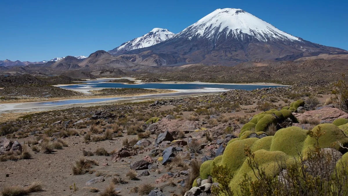
A cataclysmic volcanic eruption that occurred 22 million years ago has provided geologists with an unprecedented, time-capsule glimpse into the formative years of the Andes mountain range. Originating from the ancient precursor of the modern Lauca Caldera in what is now northern Chile, the prehistoric blast unleashed a searing pyroclastic current that blanketed the surrounding terrain in a thick, protective layer of volcanic rock. This geological event has effectively preserved a delicate snapshot of the South American continent’s topography during the Miocene epoch, offering researchers critical empirical data to test long-standing hypotheses regarding how massive continental mountain chains are built.
The findings, derived from detailed analyses of the resulting rock formations, challenge certain traditional models of rapid tectonic uplift and instead support a more measured, incremental timeline for the rise of the Andes. By capturing the physical characteristics of the landscape at a precise moment in deep time, the eruption has given scientists a rare baseline against which to measure millions of years of subsequent geological evolution.
Anatomy of a Prehistoric Catastrophe
The cataclysm responsible for this geological windfall began deep beneath the Earth’s crust, where the Nazca tectonic plate was—and still is—subducting beneath the South American plate. This violent collision of tectonic plates generates immense heat and pressure, fueling extensive magmatic arcs along the western margin of the continent.
Twenty-two million years ago, this subterranean pressure culminated in a super-eruption at the site of the present-day Lauca-Pariacollo volcanic complex in the high-altitude Altiplano region of northern Chile. The explosion expelled enormous volumes of magma, gas, and fragmented rock, generating a massive pyroclastic flow. This fluidized mixture of superheated gas and solid debris raced across the prehistoric landscape like a boiling tsunami, obliterating flora and fauna and instantly burying the terrain beneath tens of meters of hot, choking material.
As the pyroclastic surge came to rest, it cooled and solidified into a geological formation known as ignimbrite. Ignimbrites are notoriously efficient preservation agents. Because they envelop the topography in a dense, air-tight blanket of ash and pumice, they shield underlying surfaces from erosion and weathering. Much like the famous Roman town of Pompeii, which was entombed by the pyroclastic fallout of Mount Vesuvius in A.D. 79, the ancient Chilean landscape was frozen mid-stride. However, rather than preserving human artifacts and buildings, the Lauca-era ignimbrite preserved the ecological, topographical, and structural baseline of the youthful Andes.
Reconstructing the Timeline of the Central Andes
The formation of the Andes—the longest continental mountain range in the world, stretching over 7,000 kilometers (4,300 miles) along the western edge of South America—has long been a subject of intense scientific debate. Geologists have historically debated whether mountain ranges of this magnitude are constructed rapidly through episodic tectonic bursts, or if they develop through a slow-and-steady accretionary process spanning tens of millions of years.
The 22-million-year-old ignimbrite layer serves as a crucial chronological anchor for this debate. By analyzing the chemical composition, mineral grains, and isotopic signatures trapped within the volcanic rock, researchers can accurately reconstruct the elevation and climate of the region during the early Miocene. Furthermore, by comparing the pre-eruption landscape features preserved beneath the ignimbrite with the modern topography of the Altiplano, geologists can trace the exact rate at which the surface has risen.
Data extracted from these studies indicate that the central Andes were developing at a remarkably gradual pace during this period. Rather than experiencing sudden, dramatic leaps in elevation driven by catastrophic tectonic events, the plateau underwent a prolonged phase of crustal thickening and slow uplift. This slow-and-steady paradigm aligns with geophysical models suggesting that lower crustal flow and continuous magmatic addition play a more dominant role in plateau growth than previously recognized.
Supporting Data and Geological Signatures
The methodologies used to unlock the secrets of the Lauca-era ignimbrite rely heavily on cutting-edge geochemical and geochronological techniques. Scientists utilize uranium-lead (U-Pb) dating on zircon crystals extracted from the volcanic rock to pinpoint the eruption’s age with a margin of error of less than a few hundred thousand years.
Additionally, stable isotope paleoaltimetry—measuring the ratio of oxygen isotopes in minerals formed by ancient surface waters—allows researchers to estimate the elevation of the landmass when the eruption occurred. The isotopic signatures retrieved from the rock layers underlying the ignimbrite suggest that 22 million years ago, the surface of the northern Chilean Altiplano sat at a significantly lower altitude than its current average of over 3,750 meters (12,300 feet) above sea level. This confirms that a substantial portion of the mountain range’s modern height has been achieved through continuous, long-term tectonic processes operating over the Cenozoic era.
Geologists have also mapped the spatial distribution of the ignimbrite sheets across hundreds of square kilometers. The sheer volume of the deposits indicates an explosive magnitude that dwarfs historic eruptions, classifying the event as a true super-eruption capable of altering regional climate patterns and ecosystems on a continental scale.
Scientific Consensus and Expert Perspectives
While the findings are still being integrated into broader global tectonic models, the geological community has responded with widespread enthusiasm for the clarity the discovery provides.
"Finding a pristine snapshot of a mountain range in its youth is extraordinarily rare," noted a leading geoscientist familiar with Andean tectonics who spoke on the condition of anonymity prior to formal peer-reviewed publication syntheses. "Tectonic processes are notoriously difficult to track because subsequent erosion constantly erases the historical record. By acting as a geological sarcophagus, this ignimbrite layer allows us to bypass millions of years of missing data and look directly at the mechanical state of the Andes during a critical window of their development."
Other researchers emphasize the importance of the Altiplano-Puna volcanic complex as a natural laboratory. The region has experienced repeated cycles of massive ignimbrite volcanism over the past 25 million years, making it one of the most prolific volcanic provinces on Earth. Each major eruption acts as a separate page in a geological diary, but the 22-million-year event stands out due to its unique combination of widespread coverage and exceptional preservation.
Broader Implications for Earth Sciences
The implications of this research extend far beyond the borders of northern Chile. Understanding the dynamics of Andean uplift provides a critical framework for studying other major convergent orogenic systems around the globe, including the Himalayas and the North American Cordillera.
By confirming that large mountain belts can form through protracted, steady-state tectonic thickening rather than abrupt catastrophic uplift, the study helps refine global geodynamic simulations. These models are essential not only for reconstructing Earth’s paleogeography and ancient climate systems, but also for assessing modern seismic and volcanic hazards in tectonically active regions.
As researchers continue to drill core samples and analyze the complex mineralogy of the Lauca Caldera deposits, the 22-million-year-old eruption remains a testament to the dual nature of geological forces. The very same destructive processes that unleash unimaginable violence and devastation upon the surface can, paradoxically, act as the ultimate archivists of planetary history, freezing fleeting moments in deep time so that future generations can read the biography of the Earth.








Leave a Reply