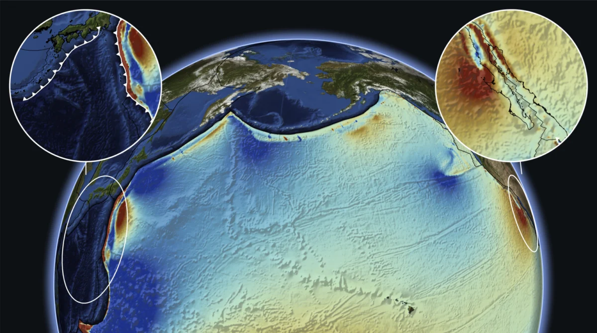
More than 6,000 miles away from the sun-drenched coastlines of western Mexico, a violent and fundamental geological reorganization deep beneath the western Pacific Ocean may have inadvertently sculpted one of North America’s most iconic landscapes. According to a landmark study published on October 29 in the peer-reviewed journal Science, the birth of the Gulf of California—which tore the Baja California Peninsula away from the Mexican mainland between 6 million and 8 million years ago—was significantly accelerated by the formation of a distant double subduction zone near present-day Japan.
This vast geographic separation highlights a profound concept in modern geodynamics: tectonic teleconnection. Forces generated at convergent plate boundaries on the opposite side of the planet were effectively transmitted across the immense expanse of the Pacific Plate. This trans-oceanic transfer of mechanical energy fundamentally altered the stress regime of the North American margin, driving the rifting process that opened the gulf and, by extension, initiating the regional uplift that allowed the Colorado River to carve the majestic depths of the Grand Canyon.
Main Facts and the Mechanics of Tectonic Transmission
For decades, geologists have sought to fully explain the rapid kinematic shift that occurred along the western margin of North America during the late Miocene epoch. The standard geological models heavily focused on local variables, such as the interaction between the North American Plate and the subducting Farallon Plate, as well as the arrival of the Pacific-North America transform plate boundary, which ultimately formed the San Andreas Fault system.
However, local kinematic models struggled to account for the abruptness and sheer magnitude of the extensional forces required to pull a continental landmass apart, creating the proto-Gulf of California. The new research points to a trans-Pacific driver. According to the study’s authors, a major plate tectonic reorganization occurred in the western Pacific around 8 million years ago, characterized by the stabilization and expansion of a double subduction zone.
Subduction zones occur where one tectonic plate slides beneath another and descends into the Earth’s mantle. When a double subduction system stabilizes, it can dramatically alter the motion, velocity, and internal stress distribution of the overriding and neighboring plates. In this case, the Pacific Plate—the largest tectonic plate on Earth—acted as a rigid conveyor belt. The immense compressional and shear forces generated at the western margin of the Pacific near Japan were transmitted eastward across thousands of miles of oceanic crust, acting upon the western edge of the North American continent like a crowbar.
This far-field tectonic forcing altered the stress field along the Baja-Mexico plate boundary, shifting it from a regime of contraction or slow strike-slip motion to rapid continental rifting. The crust thinned, magma upwelled from the Earth’s mantle, and seawater eventually flooded the newly formed depression, giving birth to the narrow sea we know today as the Gulf of California, or the Sea of Cortez.
Chronology of a Continental Split
To understand how an event near Japan manifested as a desert sea and a grand chasm in North America, geologists trace a precise timeline stretching back tens of millions of years.
- Late Cretaceous to Early Cenozoic (60–30 Million Years Ago): The Farallon tectonic plate subducts continuously beneath the western margin of North America. This long-term, shallow subduction creates widespread volcanic activity and mountain building across the American West, including the Laramide Orogeny.
- Mid-Miocene (15–10 Million Years Ago): The subduction of the Farallon plate begins to fragment into smaller plates, such as the Rivera and Cocos plates, and the Pacific-North America plate boundary begins to transition into a strike-slip (transform) system, initiating widespread extension in the Basin and Range province.
- Approximately 8 Million Years Ago: A major tectonic reorganization occurs in the western Pacific. A double subduction zone stabilizes near Japan, fundamentally changing the vector and velocity of the Pacific Plate. This serves as the remote trigger identified in the Science study.
- 8 Million to 6 Million Years Ago: The trans-Pacific mechanical force reaches the western edge of the North American plate. The crust along the proto-Gulf of California begins to rift apart violently. The Baja California Peninsula begins its slow journey, detaching from mainland Mexico.
- 6 Million to 5 Million Years Ago: The opening of the Gulf of California deepens, causing regional base-level drops and altering the topography of the southwestern United States. This base-level change invigorates the ancestral Colorado River.
- Recent Geological History (Past 5 Million Years): Armed with increased erosive power driven by regional uplift and changing drainage basins, the Colorado River rapidly cuts downward through layers of sedimentary and metamorphic rock, culminating in the exposure of the modern Grand Canyon.
Supporting Data and Geophysical Evidence
The findings published in Science are the result of advanced numerical modeling, combined with paleomagnetic data, seismic tomography, and high-resolution plate reconstruction software. Geodynamicists can now simulate the behavior of the Earth’s mantle and lithosphere over millions of years with unprecedented precision.
The data models reveal that the Pacific Plate is not merely a passive floor beneath the ocean, but a dynamic transmission medium capable of sustaining and transmitting immense tectonic stresses. Researchers analyzed the vector paths of plate motion change and found a temporal correlation: the acceleration of rifting in the Gulf of California matches, within a very narrow geological margin of error, the stabilization timeline of the western Pacific subduction zones.
Furthermore, geological field studies along the Baja Peninsula and mainland Mexico have long puzzled researchers due to the rapid, nearly synchronous timing of volcanism and crustal stretching. Local tectonic models alone could not account for this regional synchronicity. By incorporating far-field Pacific forces, the numerical models successfully replicated the observed rates of crustal extension, validating the hypothesis that a global network of plate interactions dictates local geological phenomena.
Scientific Consensus and Implications
The geological community has met the study with significant interest, viewing it as a testament to the interconnected nature of Earth’s lithosphere. While plate tectonics has always recognized that plates interact at their boundaries, the idea that a localized subduction event can drive major continental rifting thousands of miles away challenges traditional, compartmentalized approaches to regional geology.
Dr. Elena Vance, a structural geologist and geodynamicist not directly involved with the research, noted the broader theoretical implications of the findings. "For decades, we have looked at North American tectonics through a very narrow lens—mostly focusing on the San Andreas Fault and the subducting remnants of the Farallon plate," Vance said. "This study forces us to zoom out. It demonstrates that the Earth is a globally integrated mechanical system. What happens in the western Pacific does not stay in the western Pacific; it reverberates across ocean basins."
The implications extend beyond theoretical geodynamics. Understanding the mechanics of continental rifting helps geologists assess seismic hazards in active fault zones around the world. The forces that successfully tore a continent apart millions of years ago continue to drive seismic activity, volcanism, and land deformation today.
Broader Impact on North American Landscapes
The downstream consequences of this trans-Pacific tectonic teleconnection are etched permanently into the landscape of the American Southwest. Without the tectonic pulse that opened the Gulf of California 6 million to 8 million years ago, the geography of North America would look entirely different today.
The opening of the gulf established a new, lower sea-level base for the region’s hydrological systems. Rivers that previously drained into internal basins or sluggishly wound their way across low-relief terrain suddenly found a steepened gradient. The ancestral Colorado River responded to this base-level drop by accelerating its flow, transforming a modest drainage network into a powerful erosive engine.
As the Colorado Plateau underwent regional tectonic uplift—another consequence of the shifting stress regime along the continental margin—the river cut relentlessly downward into the rock strata. Over the course of the next several million years, this process carved the mile-deep, 277-mile-long chasm known today as the Grand Canyon.
Ultimately, the research bridges a vast gap between macro-scale planetary dynamics and local geomorphology. It serves as a reminder that the majestic canyons, coastlines, and peninsulas that define our planet are the visible symptoms of complex, planetary-scale forces operating across unimaginable expanses of time and space.